
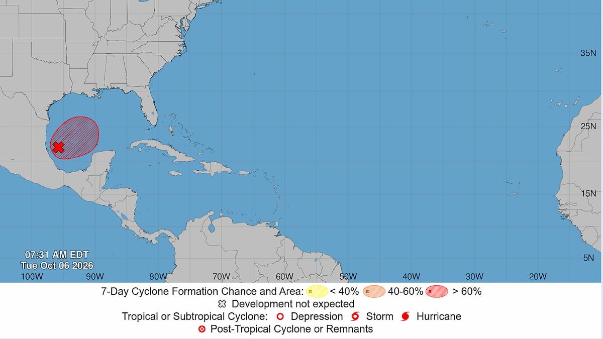
The National Hurricane Center is continuing to watch a system in the Gulf of Mexico that is shaping up to be the next tropical depression, a step away from the next named storm of the season.
On Tuesday, the hurricane center said the system was showing signs of organization, and expected the disturbance to become a tropical depression over the next day or so.
iThe system has a high chance of development — 90% — in the next two days.
“It is still too early to determine specific impacts to the northern Gulf Coast,” the hurricane center said in a morning update. “But interests from the Florida Panhandle to Louisiana should closely monitor the progress of this system.”
The next named storm of the season will be Isaias.
Forecasters expect the system to drift east and make a turn north or northeast toward the Gulf Coast by the end of the week. But just where it will end up, and how strong it will be, remains murky.
On Tuesday, Tampa Bay meteorologists agreed that the system was not a threat to Tampa Bay. Model guidance largely showed the system will likely end up somewhere between Louisiana and the Florida Panhandle.
“Impacts on the Bay Area. As of now, little to none,” Denis Phillips, chief meteorologist for WFTS-Ch. 28 wrote in a social media post Tuesday.
Paul Dellegatto, chief meteorologist for WTVT-Ch. 13, shared a similar sentiment Tuesday, writing on social media: “No direct impacts are expected in our local area, other than a continuation of our currently unsettled weather pattern.”
When asked Tuesday if any model guidance showed Tampa Bay in the storm’s crosshairs, Paul Close, a meteorologist for the National Weather Service, said, “Not at this time. There’s been nothing showing that, no.”
However, until the system forms and develops a better circulation, models will struggle to pin down what the storm may do, Close said.
Forecasters warned heavy rainfall and flooding could occur over parts of the northern Gulf Coast, the Southeast and Florida later this week, regardless of development.
A National Oceanic and Atmospheric Administration aircraft will sample the environment over the Gulf later today. And an Air Force reconnaissance plane will investigate the system tomorrow, forecasters said.
As the system drifts east, it will move through record hot Gulf waters, and meet little wind shear over the next few days, Jeff Berardelli, chief meteorologist for WFLA-Ch. 8, wrote on social media Tuesday.
However, before landfall, the system is likely to be smacked with a wall of wind shear that should weaken the storm.
No hurricanes have formed this season in what has become an unprecedented stretch of calm not seen since satellite tracking began 60 years ago. A robust El Niño has ramped up strong, widespread wind shear that has curbed chances of storm development.
Close advised residents to monitor the system as it develops and models zero in on its eventual landfall locations and intensity.
• • •
Tampa Bay Times 2026 hurricane guide
The 2026 hurricane season is here. Here’s what the forecasts say
What is a ‘super El Niño’? And what does it mean for hurricanes in Florida?
What to know about river flooding in Tampa Bay this hurricane season
Hurricane forecasts are overwhelming. Here’s how to read them
What should you pack in your storm kit? Here’s where to start
Get Times storm alerts on all your devices
How Tampa Bay seniors, others can get help evacuating
How to handle fires, tree limbs and other hazards after a storm
Here are the lessons you learned from Tampa Bay’s historic 2024 hurricane season